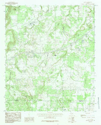
1984 Map of Santo
USGS Topo · Published 1984About this map
Santo and its surrounding countryside in the mid-1970s and early 1980s are defined by a complex network of waterways that cut through the rolling landscape. The town sits near the junction of Palo Pinto Creek and Big Sunday Creek, serving as a central point for a region characterized by its varied topography. To the northwest, the prominent heights of Clayton Mountain and Turkey Peak overlook the valley, while the terrain to the south transitions into the broken country near Bugle Mountain.
Find a feature on this map
18 named features on this map. Tap any name to fly to it.
Don’t see what you’re looking for? This feature index may not catch every label — zoom into the map to look around manually.
Map Details
Editions of this 1984 Santo Map
2 editions found
Other maps of this area

1890 · Stephenville
USGS Topo · 1:125,000

1891 · Palo Pinto
USGS Topo · 1:125,000

1918 · Palo Pinto
USGS Topo · 1:125,000

1920 · Stephenville
USGS Topo · 1:125,000

1925 · Palo Pinto 4-b
USGS Topo · 1:48,000

1931 · Santo
USGS Topo · 1:62,500

1954 · Abilene
USGS Topo · 1:250,000

1958 · Abilene
USGS Topo · 1:250,000
1959 · Lipan
USGS Topo · 1:62,500

1959 · Gordon
USGS Topo · 1:62,500