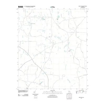
2011 Map of Sapps Lake
USGS Topo · Published 2011About this map
The Withlacoochee River and New River define the watery landscape of this South Georgia corridor, where agricultural land is segmented by numerous creeks and small family lakes. The geography of the area is heavily influenced by private water management, visible through a series of named impoundments including Sapps Lake, McMillian Lake, Lindsey Lake, and Gaskins Lake, each with its associated dam structures. These features suggest a history of local land use tied to timber, fishing, or irrigation. Local history and genealogy are anchored by specific landmarks such as Vickers Cemetery, located near Vickers Church Rd, and Flat Creek Cemetery in the eastern reaches. Transportation across the wetlands is highlighted by Gainey Bridge over the Gum Branch, while the regional road network is anchored by the historically significant Enigma Nashville Rd, which links this rural landscape to larger nearby settlements.
Find a feature on this map
51 named features on this map. Tap any name to fly to it.
Don’t see what you’re looking for? This feature index may not catch every label — zoom into the map to look around manually.
Map Details
Editions of this 2011 Sapps Lake Map
This is the sole edition of this map. No revisions or reprints were ever made.
Other maps of this area

1953 · Waycross
USGS Topo · 1:250,000

1958 · Waycross
USGS Topo · 1:250,000

1972 · Tenmile Bay
USGS Topo · 1:24,000

1973 · Adel
USGS Topo · 1:24,000

1973 · Sapps Lake
USGS Topo · 1:24,000

1973 · Nashville West
USGS Topo · 1:24,000

1973 · Enigma
USGS Topo · 1:24,000

1973 · Lenox
USGS Topo · 1:24,000

1973 · Tifton East
USGS Topo · 1:24,000
1977 · Alapaha
USGS Topo · 1:24,000