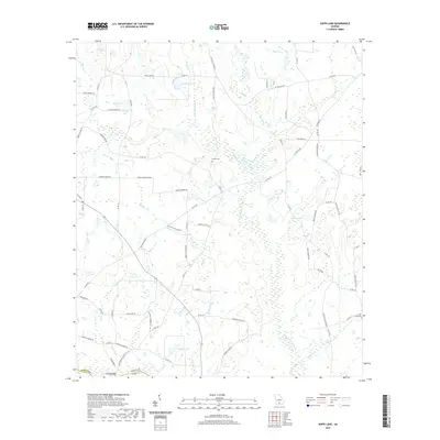
2020 Map of Sapps Lake
USGS Topo · Published 2020About this map
The Withlacoochee River carves a winding path through the southern Georgia landscape of Cook County, marking the boundary with Berrien County. This low-lying region is characterized by an intricate network of waterways, including Hardy Mill Creek, Cypress Cr, and Hog Creek, which feed into numerous cypress-lined basins. Local genealogy is anchored by family burial grounds like Vickers Cem and Flat Creek Cem, situated near the rural corridors of Nashville Enigma Rd and Sapps Lake Rd. The map reveals a high concentration of named water bodies such as Sapps Lake, McMillian Lake, and Gaskins Lake, many of which appear as natural depressions within the wetlands. At the southern edge, Gainey Bridge provides a crossing point near the confluence of Gum Br and the river, while several smaller tributaries like Wolf Branch and Poley Br drain the surrounding agricultural and timber lands.
Find a feature on this map
80 named features on this map. Tap any name to fly to it.
Don’t see what you’re looking for? This feature index may not catch every label — zoom into the map to look around manually.
Map Details
Editions of this 2020 Sapps Lake Map
This is the sole edition of this map. No revisions or reprints were ever made.
Other maps of this area

1953 · Waycross
USGS Topo · 1:250,000

1958 · Waycross
USGS Topo · 1:250,000

1972 · Tenmile Bay
USGS Topo · 1:24,000

1973 · Adel
USGS Topo · 1:24,000

1973 · Sapps Lake
USGS Topo · 1:24,000

1973 · Nashville West
USGS Topo · 1:24,000

1973 · Enigma
USGS Topo · 1:24,000

1973 · Lenox
USGS Topo · 1:24,000

1973 · Tifton East
USGS Topo · 1:24,000
1977 · Alapaha
USGS Topo · 1:24,000