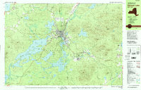
1979 Map of Saranac Lake
USGS Topo · Published 1979About this map
Saranac Lake and the surrounding wilderness of the Adirondack Park appear here during a transformative period for the region. The map captures the complex layout of the village center, including local institutions like St Bernards Sch, the Saranac Lake High Sch, and the North Country Community College campus. The northern reach of the village includes the historic Trudeau area, while the southern expansion near the border of Franklin and Essex Counties shows the Olympic Village and Correctional Institution at Ray Brook.
Find a feature on this map
110 named features on this map. Tap any name to fly to it.
Don’t see what you’re looking for? This feature index may not catch every label — zoom into the map to look around manually.
Map Details
Editions of this 1979 Saranac Lake Map
2 editions found
Other maps of this area

1895 · Mt. Marcy
USGS Topo · 1:62,500

1896 · Lake Placid
USGS Topo · 1:62,500

1898 · Lake Placid
USGS Topo · 1:62,500

1902 · Mt. Marcy
USGS Topo · 1:62,500

1902 · Saranac
USGS Topo · 1:62,500

1904 · Saranac
USGS Topo · 1:62,500

1904 · Santanoni
USGS Topo · 1:62,500

1904 · Long Lake
USGS Topo · 1:62,500

1905 · Saint Regis
USGS Topo · 1:62,500

1948 · Ogdensburg
USGS Topo · 1:250,000