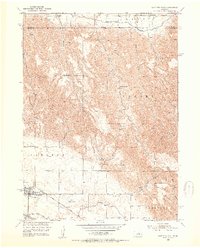
1952 Map of Sargent East
USGS Topo · Published 1954About this map
Sargent sits at the southwestern edge of this landscape, serving as a hub for the agricultural communities that developed along the Middle Loup R in the mid-20th century. The intricate irrigation network, including the Taylor-Ord Canal and Quincy Canal, illustrates the essential engineering required to sustain farming in this part of Custer County. Transport and logistics of the era are anchored by the Chicago Burlington and Quincy railroad and the Sargent Landing Field, which provided both rail and air connections to the wider region.
Find a feature on this map
27 named features on this map. Tap any name to fly to it.
Don’t see what you’re looking for? This feature index may not catch every label — zoom into the map to look around manually.
Map Details
Editions of this 1952 Sargent East Map
3 editions found
Other maps of this area

1952 · Burwell
USGS Topo · 1:24,000

1952 · Sargent East
USGS Topo · 1:24,000

1952 · Sargent SE
USGS Topo · 1:24,000

1952 · Sargent West
USGS Topo · 1:24,000

1952 · Comstock
USGS Topo · 1:24,000

1952 · Taylor SE
USGS Topo · 1:24,000

1952 · Sargent SW
USGS Topo · 1:24,000

1952 · Comstock NW
USGS Topo · 1:24,000

1952 · Taylor
USGS Topo · 1:24,000

1955 · Broken Bow
USGS Topo · 1:250,000