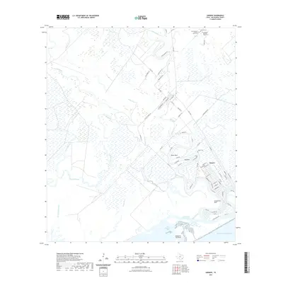
2022 Map of Sargent
USGS Topo · Published 2022About this map
Caney Creek winds through the low-lying coastal plains of Matagorda County before reaching the Intracoastal Waterway and the edge of East Matagorda Bay. This landscape is defined by its intricate network of bayous and drainage ditches, including Boggy Bayou, Live Oak Bayou, and the Jackson Ditch, which drain the wetlands behind the Matagorda Peninsula. The community of Sargent serves as a focal point near the coast, where the creek makes a series of dramatic loops at Walker Bend, Red Bend, and Carancahua Bend. For genealogists and local historians, several burial sites are preserved here, including the Bethlehem Christian Church Cem, New Bethlehem Christian Church Cem, Petteway Cem, and Sargent Cem. The road network, including FM 457 Hwy, reflects a mix of traditional ranch roads and residential development catering to the coastal environment.
Find a feature on this map
74 named features on this map. Tap any name to fly to it.
Don’t see what you’re looking for? This feature index may not catch every label — zoom into the map to look around manually.
Map Details
Editions of this 2022 Sargent Map
This is the sole edition of this map. No revisions or reprints were ever made.
Other maps of this area

1951 · Bay City
USGS Topo · 1:250,000

1952 · Lake Austin
USGS Topo · 1:24,000

1952 · Cedar Lane NE
USGS Topo · 1:24,000

1952 · Dressing Point
USGS Topo · 1:24,000

1952 · Cedar Lakes West
USGS Topo · 1:24,000
1952 · Brown Cedar Cut
USGS Topo · 1:24,000

1952 · Bay City NE
USGS Topo · 1:24,000

1952 · Cedar Lane
USGS Topo · 1:24,000

1952 · Sargent
USGS Topo · 1:24,000

1956 · Bay City
USGS Topo · 1:250,000