
1952 Map of Lake Austin
USGS Topo · Published 1953About this map
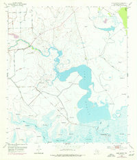
Industrial and hydrological engineering define the coastal landscape of Matagorda County in the early 1950s. The prominence of Lake Austin is complemented by an intricate network of waterways, including Peyton Creek and Canoe Bayou, which are intersected by an extensive system of man-made Levee structures. These levees follow the contours of the wetlands and marshes, particularly near Big Boggy Creek, reflecting a mid-century effort to manage the local water table and protect the surrounding terrain.
Find a feature on this map
14 named features on this map. Tap any name to fly to it.
Don’t see what you’re looking for? This feature index may not catch every label — zoom into the map to look around manually.
Map Details
Editions of this 1952 Lake Austin Map
2 editions found
Other maps of this area

1951 · Bay City
USGS Topo · 1:250,000

1952 · Matagorda
USGS Topo · 1:24,000

1952 · Dressing Point
USGS Topo · 1:24,000
1952 · Brown Cedar Cut
USGS Topo · 1:24,000

1952 · Bay City
USGS Topo · 1:24,000

1952 · Bay City NE
USGS Topo · 1:24,000

1952 · Cedar Lane
USGS Topo · 1:24,000

1952 · Sargent
USGS Topo · 1:24,000

1952 · Wadsworth
USGS Topo · 1:24,000

1956 · Bay City
USGS Topo · 1:250,000