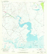
1952 Map of Lake Austin
USGS Topo · Published 1976About this map
Hydrology dominates this coastal landscape in Matagorda County, where Lake Austin and several smaller water bodies like Lake Kilbride and Pelton Lake punctuate the low-lying terrain. The map reveals an intricate network of waterways, including the winding Peyton Creek and Big Boggy Creek, alongside numerous tidal inlets such as Live Oak Bayou and Chinquapin Bayou. A striking industrial footprint is evident through dozens of numbered artesian points, such as Flowing Well 11 and Flowing Well 6, which indicate significant groundwater management or ranching infrastructure during this era. Protective Levee systems follow the contours of the wetlands, reflecting the ongoing efforts to manage the transition between the freshwater systems and the marshy coastal plains. This 1952 survey, with later 1970s revisions, also documents early aviation and energy interests through a rural Landing Strip and scattered Oil Wells.
Find a feature on this map
33 named features on this map. Tap any name to fly to it.
Don’t see what you’re looking for? This feature index may not catch every label — zoom into the map to look around manually.
Map Details
Editions of this 1952 Lake Austin Map
2 editions found
Other maps of this area

1951 · Bay City
USGS Topo · 1:250,000

1952 · Lake Austin
USGS Topo · 1:24,000

1952 · Matagorda
USGS Topo · 1:24,000

1952 · Dressing Point
USGS Topo · 1:24,000
1952 · Brown Cedar Cut
USGS Topo · 1:24,000

1952 · Bay City
USGS Topo · 1:24,000

1952 · Bay City NE
USGS Topo · 1:24,000

1952 · Cedar Lane
USGS Topo · 1:24,000

1952 · Sargent
USGS Topo · 1:24,000

1952 · Wadsworth
USGS Topo · 1:24,000