
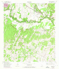
1958 Map of Saspamco
USGS Topo · Published 1961About this map
The San Antonio River meanders across this late-1950s landscape, serving as a geographic anchor for small settlements like Graytown and Saspamco. The industrial character of the region is evidenced by the Sandpits near the riverbanks and the presence of the Southern Pacific railroad, which provided the necessary transit for local resources. To the east, the Bexar Co and Wilson Co border bisects the rural terrain, where the small communities of Calaveras and Canada Verde are situated along the tributaries of Calaveras Creek. For genealogists and local historians, the map identifies key community pillars such as Guadalupe Ch, Conception Ch, and several rural Cem sites. The landscape transitions from the river bottomlands to more broken country toward the south, where Padre Mariolo Creek flows through the brush and farmland.
Find a feature on this map
13 named features on this map. Tap any name to fly to it.
Don’t see what you’re looking for? This feature index may not catch every label — zoom into the map to look around manually.
Map Details
Editions of this 1958 Saspamco Map
2 editions found
Other maps of this area

1936 · Floresville
USGS Topo · 1:62,500

1953 · Elmendorf
USGS Topo · 1:24,000

1953 · Southton
USGS Topo · 1:24,000

1954 · San Antonio
USGS Topo · 1:250,000

1957 · San Antonio
USGS Topo · 1:250,000

1958 · Losoya
USGS Topo · 1:24,000

1958 · La Vernia SW
USGS Topo · 1:24,000
1961 · Dewees
USGS Topo · 1:24,000
1961 · Floresville
USGS Topo · 1:24,000
1964 · Saspamco SE
USGS Topo · 1:24,000