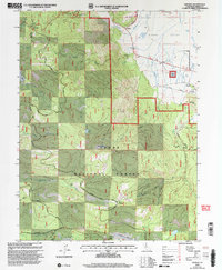
2000 Map of Sattley
USGS Topo · Published 2003About this map
The Sierra Valley edge meets the steep timberlands of the Tahoe National Forest in this millennium-era update of eastern Sierra County. The small community of Sattley sits at the junction where the Donner Scenic Byway enters the valley floor from the west. This landscape is a patchwork of early ranching and logging history, evidenced by the Nichols Mill (Site) and the Sierraville Cemetery on the eastern margin. Higher elevations are marked by seasonal outposts and high-altitude passage points like the Ahart Sheep Camp and the historic Henness Pass route. The drainage patterns of Turner Creek and Bonta Creek define the descent from the mountain peaks toward the wide, flat valley, providing a clear picture of the region's hydraulic and topographic character before modern development intensified.
Find a feature on this map
47 named features on this map. Tap any name to fly to it.
Don’t see what you’re looking for? This feature index may not catch every label — zoom into the map to look around manually.
Map Details
Editions of this 2000 Sattley Map
This is the sole edition of this map. No revisions or reprints were ever made.
Other maps of this area

1890 · Sierraville
USGS Topo · 1:125,000

1891 · Downieville
USGS Topo · 1:125,000

1891 · Colfax
USGS Topo · 1:125,000

1891 · Truckee
USGS Topo · 1:125,000

1892 · Sierraville
USGS Topo · 1:125,000

1892 · Colfax
USGS Topo · 1:125,000

1893 · Truckee
USGS Topo · 1:125,000

1893 · Downieville
USGS Topo · 1:125,000

1894 · Colfax
USGS Topo · 1:125,000

1894 · Sierraville
USGS Topo · 1:125,000