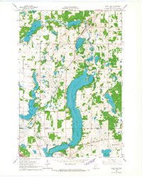
1966 Map of Sauk Lake
USGS Topo · Published 1967About this map
The glacial lakes and wetlands of Todd County dominate this mid-century landscape, centered on the expansive waters of Sauk Lake. Small lakeside settlements and rural institutions define the human footprint, from the clustered buildings of Little Sauk in the north to the Minnesota Home School campus and Sauk Centre at the southern tip of the lake. Local infrastructure in the 1960s was supported by the Great Northern railroad line, which bisects the western half of the map, and the Pacific Northern road.
Find a feature on this map
33 named features on this map. Tap any name to fly to it.
Don’t see what you’re looking for? This feature index may not catch every label — zoom into the map to look around manually.
Map Details
Editions of this 1966 Sauk Lake Map
This is the sole edition of this map. No revisions or reprints were ever made.
Other maps of this area

1953 · Saint Cloud
USGS Topo · 1:250,000

1957 · Saint Cloud
USGS Topo · 1:250,000

1958 · Saint Cloud
USGS Topo · 1:250,000

1965 · Sauk Centre
USGS Topo · 1:24,000

1965 · Melrose
USGS Topo · 1:24,000

1965 · Raymond Lake
USGS Topo · 1:24,000

1966 · West Union
USGS Topo · 1:24,000
1966 · Long Prairie
USGS Topo · 1:24,000

1966 · Lake Osakis East
USGS Topo · 1:24,000
1966 · Round Prairie
USGS Topo · 1:24,000