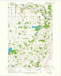
1966 Map of Round Prairie
USGS Topo · Published 1967About this map
Long Prairie River meanders through the northeast corner of this Todd County landscape, defining a region where glacial lakes and agricultural persistence intersect. The settlement of Round Prairie sits along the Great Northern railroad line, serving as a focal point for the surrounding rural townships of Reynolds and Little Sauk. Small, community-centered landmarks provide essential data for local historians, including the Reynolds Ch, the nearby Reynolds Cem, and School No 2283 located near the southern Mud Lake. The terrain is punctuated by numerous bodies of water like McCarrahan Lake and Maple Lake, while the frequent notation of Gravel Pits suggests the local importance of aggregate extraction for road building and infrastructure during the mid-1960s.
Find a feature on this map
17 named features on this map. Tap any name to fly to it.
Don’t see what you’re looking for? This feature index may not catch every label — zoom into the map to look around manually.
Map Details
Editions of this 1966 Round Prairie Map
This is the sole edition of this map. No revisions or reprints were ever made.
Other maps of this area

1953 · Brainerd
USGS Topo · 1:250,000

1953 · Saint Cloud
USGS Topo · 1:250,000

1957 · Brainerd
USGS Topo · 1:250,000

1957 · Saint Cloud
USGS Topo · 1:250,000

1958 · Saint Cloud
USGS Topo · 1:250,000

1958 · Brainerd
USGS Topo · 1:250,000

1965 · Brainerd
USGS Topo · 1:250,000

1966 · West Union
USGS Topo · 1:24,000
1966 · Browerville
USGS Topo · 1:24,000
1966 · Sauk Lake
USGS Topo · 1:24,000