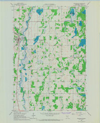
1966 Map of Browerville
USGS Topo · Published 1967About this map
The Long Prairie River carves a winding path through Todd County, anchoring the settlement of Browerville. This mid-1960s landscape is characterized by a high concentration of glacial lakes and wetlands, including Horseshoe Lake, Jacobs Lake, and Meyer Lake, several of which are preserved within the Turtle Creek State Wildlife Management Area. The town itself serves as a local hub along the Great Northern railroad line, featuring a High Sch and municipal infrastructure like a Water Tank and Sewage Disposal Pond.
Find a feature on this map
35 named features on this map. Tap any name to fly to it.
Don’t see what you’re looking for? This feature index may not catch every label — zoom into the map to look around manually.
Map Details
Editions of this 1966 Browerville Map
This is the sole edition of this map. No revisions or reprints were ever made.
Other maps of this area

1948 · Cushing
USGS Topo · 1:62,500

1950 · Swanville
USGS Topo · 1:62,500

1950 · Cushing
USGS Topo · 1:62,500

1953 · Brainerd
USGS Topo · 1:250,000

1953 · Saint Cloud
USGS Topo · 1:250,000

1957 · Brainerd
USGS Topo · 1:250,000

1957 · Saint Cloud
USGS Topo · 1:250,000

1958 · Saint Cloud
USGS Topo · 1:250,000

1958 · Brainerd
USGS Topo · 1:250,000

1965 · Brainerd
USGS Topo · 1:250,000