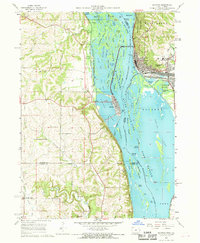
1967 Map of Savanna
USGS Topo · Published 1968About this map
The Mississippi River creates a complex network of islands and backwater lakes along the border of Iowa and Illinois in the late 1960s. Savanna sits on the eastern bank, its grid extending toward Mississippi Palisades State Park and the Chicago Burlington & Quincy railroad tracks. Across the water, the town of Sabula occupies a narrow island linked to the mainland by the Chicago Milwaukee St Paul and Pacific line. The landscape is dotted with several rural cemeteries, including Dickinson Cem and Canada Hollow Cem, serving the farming communities of Union and Elk River townships. To the south, the river widens into the Savanna Spring Lake and the Fish Refuge, where numerous named islands like Cook Island and Mound Island dominate the waterway, reflecting an era before modern hydrological shifts altered these riparian corridors.
Find a feature on this map
76 named features on this map. Tap any name to fly to it.
Don’t see what you’re looking for? This feature index may not catch every label — zoom into the map to look around manually.
Map Details
Editions of this 1967 Savanna Map
4 editions found
Other maps of this area

1891 · Clinton
USGS Topo · 1:62,500

1892 · Goose Lake
USGS Topo · 1:62,500

1892 · Savanna
USGS Topo · 1:62,500

1894 · Goose Lake
USGS Topo · 1:62,500

1894 · Clinton
USGS Topo · 1:62,500

1899 · Clinton
USGS Topo · 1:125,000

1935 · Miles
USGS Topo · 1:62,500

1941 · Miles
USGS Topo · 1:62,500

1952 · Clinton
USGS Topo · 1:62,500

1952 · Savanna
USGS Topo · 1:62,500