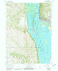
1967 Map of Savanna
USGS Topo · Published 1983About this map
The Mississippi River creates a complex landscape of sloughs and islands here, defining the border between Carroll County, Illinois, and Jackson and Clinton Counties in Iowa. On the eastern shore, Savanna sits at the foot of the bluffs within the Mississippi Palisades State Park, while the town of Sabula occupies a narrow island across the main channel. The region is characterized by extensive wetlands and conservation areas, including the Savanna National Wild Life and Fish Refuge and the labyrinthine Sabula Lakes.
Find a feature on this map
74 named features on this map. Tap any name to fly to it.
Don’t see what you’re looking for? This feature index may not catch every label — zoom into the map to look around manually.
Map Details
Editions of this 1967 Savanna Map
4 editions found
Other maps of this area

1891 · Clinton
USGS Topo · 1:62,500

1892 · Goose Lake
USGS Topo · 1:62,500

1892 · Savanna
USGS Topo · 1:62,500

1894 · Goose Lake
USGS Topo · 1:62,500

1894 · Clinton
USGS Topo · 1:62,500

1899 · Clinton
USGS Topo · 1:125,000

1935 · Miles
USGS Topo · 1:62,500

1941 · Miles
USGS Topo · 1:62,500

1952 · Clinton
USGS Topo · 1:62,500

1952 · Savanna
USGS Topo · 1:62,500