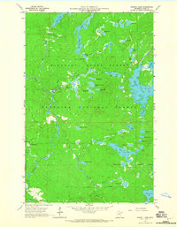
1960 Map of Sawbill Camp
USGS Topo · Published 1965About this map
Minnesota State Forest and Superior National Forest dominate this 1960 landscape, revealing a remote wilderness shaped by the timber and transportation networks of the North Woods. The map documents the persistent marks of the logging era, specifically the Temperance River Railroad Grade and an Old Railroad Grade that cut through the dense topography. These corridors, alongside the primitive Sawbill Road, provided the essential arteries for resource extraction before the area's transition toward recreation.
Find a feature on this map
64 named features on this map. Tap any name to fly to it.
Don’t see what you’re looking for? This feature index may not catch every label — zoom into the map to look around manually.
Map Details
Editions of this 1960 Sawbill Camp Map
4 editions found
Other maps of this area

1919 · Brule Lake
USGS Topo · 1:62,500

1919 · Lutsen
USGS Topo · 1:62,500

1954 · Two Harbors
USGS Topo · 1:250,000

1955 · Tofte
USGS Topo · 1:62,500

1957 · Two Harbors
USGS Topo · 1:250,000

1958 · Two Harbors
USGS Topo · 1:250,000

1959 · Lutsen
USGS Topo · 1:24,000

1960 · Tait Lake
USGS Topo · 1:24,000

1960 · Sawbill Camp
USGS Topo · 1:24,000

1960 · Brule Lake
USGS Topo · 1:24,000