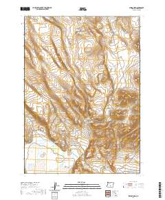
2020 Map of Sawed Horn
USGS Topo · Published 2020About this map
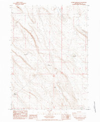
Sawed Horn and Jug Mtn anchor this high-desert landscape in Lake County, where water resources define the human footprint on the land. In this arid reach of southern Oregon, the map documents a network of critical watering points including Forks Waterhole, Brattain Waterhole Number 10, and Collins Waterhole. These features, along with Kelso Reservoir and Club Reservoir, suggest a landscape shaped by seasonal grazing and ranching requirements. The terrain is marked by significant geological formations such as Euchre Butte and the winding Shell Rock Canyon, which cuts through the volcanic geology of the region. While remote, the area is connected by local routes like Co RD 2-06, providing access to isolated springs such as XL Spring. The detailed contour lines and hydrographic data reflect a quiet, resource-focused geography typical of the Great Basin's western edge.
Find a feature on this map
16 named features on this map. Tap any name to fly to it.
Don’t see what you’re looking for? This feature index may not catch every label — zoom into the map to look around manually.
Map Details
Editions of this 2020 Sawed Horn Map
This is the sole edition of this map. No revisions or reprints were ever made.
Other maps of this area

1955 · Klamath Falls
USGS Topo · 1:250,000

1958 · Klamath Falls
USGS Topo · 1:250,000

1966 · Coglan Buttes NE
USGS Topo · 1:24,000

1968 · Lake Abert North
USGS Topo · 1:24,000

1968 · Commodore Ridge
USGS Topo · 1:24,000

1974 · Lake Abert
USGS Topo · 1:100,000
1984 · Coleman Hills
USGS Topo · 1:24,000
1984 · Sawed Horn
USGS Topo · 1:24,000
1984 · Alkali Lake
USGS Topo · 1:24,000
1984 · Poverty Basin South
USGS Topo · 1:24,000