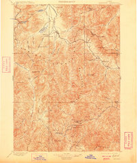
1900 Map of Sawtooth
USGS Topo · Published 1909About this map
Silver King Mine and the Columbia Mill anchor the northern reaches of this Idaho mining landscape, where early twentieth-century extraction defined the local economy and settlement patterns. The map details a network of high-altitude camps and operations, including Carrietown in the south, which served as a hub for the Silver Star Mine and the King of the West Mine. These settlements were deeply integrated with the rugged drainage systems of the South Fork Boise River and Big Smoky Creek.
Find a feature on this map
86 named features on this map. Tap any name to fly to it.
Don’t see what you’re looking for? This feature index may not catch every label — zoom into the map to look around manually.
Map Details
Editions of this 1900 Sawtooth Map
4 editions found
Other maps of this area

1891 · Bear Valley
USGS Topo · 1:125,000

1892 · Camas Prairie
USGS Topo · 1:125,000

1893 · Bear Valley
USGS Topo · 1:125,000

1893 · Camas Prairie
USGS Topo · 1:125,000

1894 · Rocky Bar
USGS Topo · 1:125,000

1895 · Hailey
USGS Topo · 1:125,000

1897 · Hailey
USGS Topo · 1:125,000

1900 · Sawtooth
USGS Topo · 1:125,000

1919 · Custer
USGS Topo · 1:125,000

1922 · Custer
USGS Topo · 1:125,000