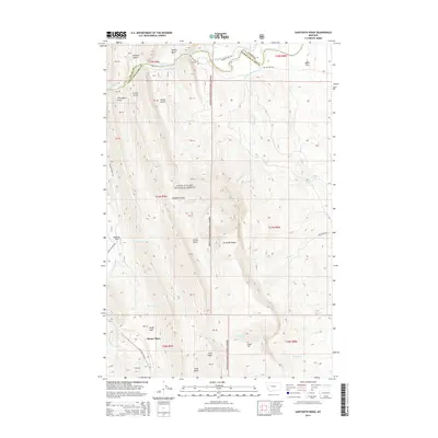
2014 Map of Sawtooth Ridge
USGS Topo · Published 2014About this map
Stoner Place sits at the edge of the Lewis & Clark National Forest in this 2014 topographic study of the Rocky Mountain Front. The landscape is defined by the sharp rise of the Sawtooth Ridge, a dramatic limestone formation that separates the high mountain interior from the eastern plains. Water management for the surrounding ranching and agricultural region is visible through the Sun River drainage system, which includes the Diversion Lake and the engineering of the Pishkun Canal. Historical land use patterns are etched into the terrain through local place names such as Sawmill Flat, Lime Gulch, and French Gulch. This map records the intersection of rugged wilderness and the infrastructure of the Great Plains' edge, noting the transitions from the river valleys to named plateaus like Agropyron Flats and Alkali Flat.
Find a feature on this map
39 named features on this map. Tap any name to fly to it.
Don’t see what you’re looking for? This feature index may not catch every label — zoom into the map to look around manually.
Map Details
Editions of this 2014 Sawtooth Ridge Map
This is the sole edition of this map. No revisions or reprints were ever made.
Other maps of this area

1903 · Saypo
USGS Topo · 1:125,000

1903 · Coopers Lake
USGS Topo · 1:125,000

1955 · Choteau
USGS Topo · 1:250,000

1957 · Choteau
USGS Topo · 1:250,000

1958 · Choteau
USGS Topo · 1:250,000

1958 · Barr Creek
USGS Topo · 1:24,000

1958 · Sawtooth Ridge
USGS Topo · 1:24,000

1958 · Patricks Basin
USGS Topo · 1:24,000

1958 · Castle Reef
USGS Topo · 1:24,000
1958 · Split Rock Lake
USGS Topo · 1:24,000