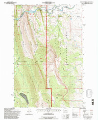
1995 Map of Sawtooth Ridge
USGS Topo · Published 1997About this map
The Sun River cuts a deep path through the eastern front of the Rockies, anchoring a landscape where water management and wilderness preservation meet. In the mid-1990s, this area reflects a complex transition from high-mountain terrain in the Lewis and Clark National Forest to the managed plains below. The Diversion Dam and Diversion Lake facilitate the movement of water via a prominent Canal toward the Alkali Flat. Local tourism and ranching history is preserved through landmarks like the Sun Canyon Lodge, Neal Ranch, and Stecker Ranch, which sit near the entrance to the dramatic river canyon. High points such as Sugar Loaf and the jagged Sawtooth Ridge overlook the Sun River Wildlife Management Area, a dedicated space for habitat protection that occupies the central river valley.
Find a feature on this map
34 named features on this map. Tap any name to fly to it.
Don’t see what you’re looking for? This feature index may not catch every label — zoom into the map to look around manually.
Map Details
Editions of this 1995 Sawtooth Ridge Map
This is the sole edition of this map. No revisions or reprints were ever made.
Other maps of this area

1903 · Saypo
USGS Topo · 1:125,000

1903 · Coopers Lake
USGS Topo · 1:125,000

1955 · Choteau
USGS Topo · 1:250,000

1957 · Choteau
USGS Topo · 1:250,000

1958 · Choteau
USGS Topo · 1:250,000

1958 · Barr Creek
USGS Topo · 1:24,000

1958 · Sawtooth Ridge
USGS Topo · 1:24,000

1958 · Patricks Basin
USGS Topo · 1:24,000

1958 · Castle Reef
USGS Topo · 1:24,000
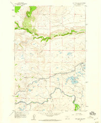
1958 · Split Rock Lake
USGS Topo · 1:24,000