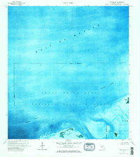
1972 Map of Sawyer Key
USGS Topo · Published 1973About this map
The Great White Heron National Wildlife Refuge dominates this marine-focused orthophotomap, which utilizes aerial imagery from 1970 to document the intricate shallow-water environments of the Florida Keys. Unlike traditional line maps, this survey uses photographic layers to show the shifting shoals and submerged banks within the Gulf of Mexico. The southwestern corner reveals the small, mangrove-lined landmass of Sawyer Key and the adjacent Riding Key, while the southeastern edge identifies the northern portion of the National Key Deer Refuge near Crane Key. These protected waters are bisected by the Intracoastal Waterway, a vital transit corridor for local mariners navigating through the Cudjoe Channel. The map specifically notes an Indefinite Boundary throughout the area, reflecting the complex and ever-changing nature of these coastal Florida jurisdictions and shorelines.
Find a feature on this map
11 named features on this map. Tap any name to fly to it.
Don’t see what you’re looking for? This feature index may not catch every label — zoom into the map to look around manually.
Map Details
Editions of this 1972 Sawyer Key Map
2 editions found
Other maps of this area

1921 · Sugar Loaf Key
USGS Topo · 1:62,500

1943 · Snipe Keys
USGS Topo · 1:24,000

1943 · Sugarloaf Key
USGS Topo · 1:24,000
1972 · Sawyer Key
USGS Topo · 1:24,000

1972 · Content Keys
USGS Topo · 1:24,000
1972 · Snipe Keys
USGS Topo · 1:24,000

1972 · Summerland Key
USGS Topo · 1:24,000
1972 · Sugarloaf Key
USGS Topo · 1:24,000

1983 · Key West
USGS Topo · 1:100,000

1989 · Key West
USGS Topo · 1:250,000