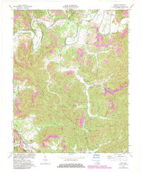
1970 Map of Saxton
USGS Topo · Published 1983About this map
Coal extraction and river geography define this section of Whitley County, where the Cumberland River carves dramatic loops through Horseshoe Bend, Maiden Bend, and Boyd Bend. The industrial character of the 1970s is evident in the extensive Strip Mine operations and individual Mine shafts scattered across the slopes of Patterson Mountain and Powers Mtn. These operations are linked by the Louisville and Nashville railroad, which follows the creek valleys to service mining settlements like Gatliff and Nevisdale. Away from the industrial zones, local life is anchored by landmarks like Nevisdale Sch, Mt Pisgah Ch, and Mulberry Ch. The terrain transitions from the river lowlands to the higher elevations of Bowing Mountain and Taylor Mountain, with several family-named cemeteries and hollows marking the heritage of the Cumberland plateau.
Find a feature on this map
61 named features on this map. Tap any name to fly to it.
Don’t see what you’re looking for? This feature index may not catch every label — zoom into the map to look around manually.
Map Details
Editions of this 1970 Saxton Map
2 editions found
Other maps of this area

1886 · Cumberland Gap
USGS Topo · 1:125,000

1888 · Cumberland Gap
USGS Topo · 1:125,000

1890 · Williamsburg
USGS Topo · 1:125,000

1891 · Cumberland Gap
USGS Topo · 1:125,000

1894 · Williamsburg
USGS Topo · 1:125,000

1952 · Wofford
USGS Topo · 1:24,000

1952 · Barbourville
USGS Topo · 1:24,000

1952 · Saxton
USGS Topo · 1:24,000

1952 · Rockholds
USGS Topo · 1:24,000

1952 · Williamsburg
USGS Topo · 1:24,000