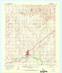
1960 Map of Sayre
USGS Topo · Published 1968About this map
Sayre serves as the central hub of Beckham County in this mid-century survey, positioned where the Chicago Rock Island and Pacific railroad crosses the North Fork Red River. The landscape is a network of small agricultural settlements and rural gathering places, including Berlin, New Liberty, and Doxey. Local history is deeply etched into the terrain through numerous community landmarks such as Lone Oak Ch, New Victory Ch, and Rosehill Cem. The influence of the regional petroleum industry is evident in the southeastern corner with the Elk City Oil Field. Transportation patterns show a mix of established rail lines and early highway development, with the iconic Route 66 running through the heart of the area. This era captures the transition from a purely agrarian economy to one shaped by energy extraction and modern road travel.
Find a feature on this map
45 named features on this map. Tap any name to fly to it.
Don’t see what you’re looking for? This feature index may not catch every label — zoom into the map to look around manually.
Map Details
Editions of this 1960 Sayre Map
2 editions found
Other maps of this area

1955 · Clinton
USGS Topo · 1:250,000

1957 · Clinton
USGS Topo · 1:250,000

1960 · Sweetwater
USGS Topo · 1:62,500

1960 · Cheyenne
USGS Topo · 1:62,500

1960 · Sayre
USGS Topo · 1:62,500

1960 · Hammon
USGS Topo · 1:62,500

1961 · Reydon
USGS Topo · 1:62,500

1961 · Willow
USGS Topo · 1:62,500

1961 · Erick
USGS Topo · 1:62,500

1961 · Retrop
USGS Topo · 1:62,500