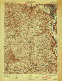
1942 Map of Sayre
USGS Topo · Published 1942About this map
The Chemung River and Susquehanna River converge at the northern edge of this Pennsylvania landscape, where the rail-centered industrial hubs of Sayre, Athens, and South Waverly dominate the topography. These riverside settlements are tightly interconnected by the Lehigh Valley RR and a network of arterial highways, reflecting a mid-century period of established transportation and trade. Further south, the terrain transitions into a patchwork of rural townships, including Smithfield and Burlington, where the settlement pattern is defined by crossroad hamlets and local infrastructure.
Find a feature on this map
74 named features on this map. Tap any name to fly to it.
Don’t see what you’re looking for? This feature index may not catch every label — zoom into the map to look around manually.
Map Details
Editions of this 1942 Sayre Map
2 editions found

Other maps of this area

1895 · Elmira
USGS Topo · 1:62,500

1902 · Waverly
USGS Topo · 1:62,500

1903 · Owego
USGS Topo · 1:62,500

1905 · Watkins Glen
USGS Topo · 1:125,000

1906 · Catatonk
USGS Topo · 1:125,000

1923 · Towanda
USGS Topo · 1:62,500

1926 · Towanda
USGS Topo · 1:62,500

1931 · Troy
USGS Topo · 1:48,000

1938 · Troy
USGS Topo · 1:62,500

1939 · Sayre
USGS Topo · 1:62,500