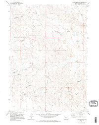
1971 Map of Scaper Reservoir
USGS Topo · Published 1995About this map
Scaper Reservoir and the surrounding range of Campbell County are defined by a high-desert network of small-scale water management and resource extraction in the early 1970s. This survey, compiled from 1970 aerial photography, reveals a landscape organized by family and place-named water catchments, including Moser Reservoir, Sand Rock Reservoir, and Romaker Reservoir. The terrain is deeply incised by drainages like Bluegate Creek and Caballo Creek, with several long draws such as School Section Draw and Romaker Draw cutting through the open country.
Find a feature on this map
33 named features on this map. Tap any name to fly to it.
Don’t see what you’re looking for? This feature index may not catch every label — zoom into the map to look around manually.
Map Details
Editions of this 1971 Scaper Reservoir Map
2 editions found
Other maps of this area

1954 · Gillette
USGS Topo · 1:250,000

1955 · Newcastle
USGS Topo · 1:250,000

1955 · Gillette
USGS Topo · 1:250,000

1958 · Gillette
USGS Topo · 1:250,000

1958 · Newcastle
USGS Topo · 1:250,000

1959 · North Star School
USGS Topo · 1:62,500

1962 · Gillette
USGS Topo · 1:250,000

1971 · Scaper Reservoir
USGS Topo · 1:24,000

1971 · The Gap SW
USGS Topo · 1:24,000
1971 · Pleasantdale
USGS Topo · 1:24,000