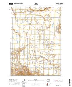
2020 Map of Schaub Lake
USGS Topo · Published 2020About this map
Fort Rock Valley defines this high desert landscape in Oregon, where a network of section-line roads and remote drainage basins reveal the organized settlement of Lake County. The terrain is characterized by large, ephemeral basins including Schaub Lake, Cream Lake, and Windmill Lake, which are situated across the arid floor of the valley. To the southwest, the Connley Hills rise above the basin floor, providing a stark topographical contrast to the flat northern reaches near the Flatiron. This survey documents a rural environment shaped by the public land survey system, as evidenced by the grid-like alignment of Fort Rock Rd and Thomas Rd, which connect isolated homesteads and ranch lands in this part of the Oregon interior.
Find a feature on this map
27 named features on this map. Tap any name to fly to it.
Don’t see what you’re looking for? This feature index may not catch every label — zoom into the map to look around manually.
Map Details
Editions of this 2020 Schaub Lake Map
This is the sole edition of this map. No revisions or reprints were ever made.
Other maps of this area

1955 · Crescent
USGS Topo · 1:250,000

1957 · Crescent
USGS Topo · 1:250,000

1958 · Crescent
USGS Topo · 1:250,000

1968 · Silver Lake
USGS Topo · 1:24,000

1970 · Crescent
USGS Topo · 1:250,000

1979 · Crescent
USGS Topo · 1:100,000

1981 · Hogback Butte
USGS Topo · 1:24,000

1981 · Cougar Mtn
USGS Topo · 1:24,000

1981 · Thorn Lake
USGS Topo · 1:24,000

1981 · Lane Lake
USGS Topo · 1:24,000