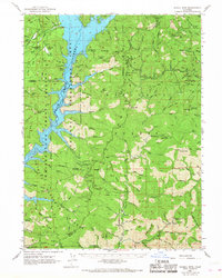
1967 Map of Schell Mtn
USGS Topo · Published 1968About this map
Clair Engle Lake dominates the western geography of this California mountain landscape, reflecting a mid-century period of major reservoir development within the Shasta National Forest. The map documents the complex topography of the Trinity Mountains, where timber and mining interests shaped the early 20th-century economy. Relics of these industries are scattered across the ridges, from the Lamoine Mill Site in the northeast to the Stoffard Shaft and Baker Mine near the southern boundary.
Find a feature on this map
127 named features on this map. Tap any name to fly to it.
Don’t see what you’re looking for? This feature index may not catch every label — zoom into the map to look around manually.
Map Details
Editions of this 1967 Schell Mtn Map
This is the sole edition of this map. No revisions or reprints were ever made.
Other maps of this area

1886 · Shasta
USGS Topo · 1:250,000

1890 · Red Bluff
USGS Topo · 1:250,000

1894 · Red Bluff
USGS Topo · 1:250,000

1894 · Shasta
USGS Topo · 1:250,000

1901 · Redding
USGS Topo · 1:125,000

1913 · Weaverville
USGS Topo · 1:125,000

1923 · Sawyers Bar
USGS Topo · 1:125,000

1931 · Etna
USGS Topo · 1:96,000

1934 · Etna
USGS Topo · 1:125,000

1935 · Dunsmuir
USGS Topo · 1:125,000