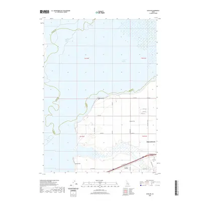
2020 Map of Schiller
USGS Topo · Published 2020About this map
American Falls Reservoir dominates the northern landscape of this region, meeting the shore at points like Bronco Beach and Rainbow Beach. The terrain transitions into the broad expanse of Michaud Flats to the south, where a grid of rural roads and agricultural development defines the land use. The western edge of Pocatello appears in the southeast corner, situated near the small settlement of Schiller. This area serves as a significant crossroads where the waters of Bannock Cr flow toward the reservoir, and major thoroughfares like the Arbon Valley Hwy connect the valley's rural homesteads to the urban periphery. The map captures the interface between industrial-scale agriculture and the water management systems of the Snake River plain, evidenced by features such as Sod Farm Rd and E Elevator Loop.
Find a feature on this map
32 named features on this map. Tap any name to fly to it.
Don’t see what you’re looking for? This feature index may not catch every label — zoom into the map to look around manually.
Map Details
Editions of this 2020 Schiller Map
This is the sole edition of this map. No revisions or reprints were ever made.
Other maps of this area

1934 · American Falls
USGS Topo · 1:62,500

1934 · Michaud
USGS Topo · 1:62,500

1936 · American Falls
USGS Topo · 1:62,500

1937 · Michaud
USGS Topo · 1:62,500

1954 · Pocatello
USGS Topo · 1:250,000

1955 · Pingree
USGS Topo · 1:24,000

1955 · Springfield
USGS Topo · 1:24,000

1955 · Idaho Falls
USGS Topo · 1:250,000

1958 · Idaho Falls
USGS Topo · 1:250,000

1958 · Pocatello
USGS Topo · 1:250,000