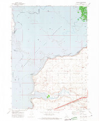
1971 Map of Schiller
USGS Topo · Published 1974About this map
The American Falls Reservoir dominates this landscape along the border of Power and Bannock counties, submerged where the Snake River and Portneuf River converge. This 1971 survey captures the hydrological and industrial footprint of the region, featuring underwater contours mapped by the U.S. Bureau of Reclamation. On the southern shore, Michaud Flats reveals a network of agricultural development and infrastructure, including the Pocatello Municipal Airport and the tracks of the Union Pacific railroad. Cultural and historical sites are scattered throughout the Fort Hall Indian Reservation, most notably the Indian Cem near the eastern margin. Local travel and recreation are evidenced by features like Rainbow Beach and the Boat Ramp, while the rural interior is defined by named thoroughfares such as Sterling Road and Gardner Road, providing a clear view of the area's mid-century layout.
Find a feature on this map
24 named features on this map. Tap any name to fly to it.
Don’t see what you’re looking for? This feature index may not catch every label — zoom into the map to look around manually.
Map Details
Editions of this 1971 Schiller Map
This is the sole edition of this map. No revisions or reprints were ever made.
Other maps of this area

1934 · American Falls
USGS Topo · 1:62,500

1934 · Michaud
USGS Topo · 1:62,500

1936 · American Falls
USGS Topo · 1:62,500

1937 · Michaud
USGS Topo · 1:62,500

1954 · Pocatello
USGS Topo · 1:250,000

1955 · Pingree
USGS Topo · 1:24,000

1955 · Springfield
USGS Topo · 1:24,000

1955 · Idaho Falls
USGS Topo · 1:250,000

1958 · Idaho Falls
USGS Topo · 1:250,000

1958 · Pocatello
USGS Topo · 1:250,000