
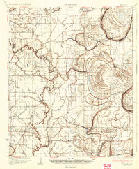
1934 Map of Schlater
USGS Topo · Published 1934About this map
The alluvial plains of the Mississippi Delta are defined here by a dense network of meandering waterways and the agricultural settlements they support. The Tallahatchie River snakes through the eastern landscape, forming the dramatic Eutah Bend near Sunnyside, while the Quiver River and its various tributaries like Rattlesnake Bayou and Howling Wolf Bayou drain the western reaches. This 1930s landscape is deeply partitioned by local institutions, featuring numerous small congregations and schools such as Rosenwald Sch, Harts Chapel, and Williams Ch that served the rural population during the height of the plantation era.
Find a feature on this map
80 named features on this map. Tap any name to fly to it.
Don’t see what you’re looking for? This feature index may not catch every label — zoom into the map to look around manually.
Map Details
Editions of this 1934 Schlater Map
2 editions found
Other maps of this area

1931 · Schlater
USGS Topo · 1:48,000

1931 · Sumner
USGS Topo · 1:48,000

1931 · Drew
USGS Topo · 1:48,000

1932 · Philipp
USGS Topo · 1:48,000

1934 · Cleveland
USGS Topo · 1:62,500

1935 · Sumner
USGS Topo · 1:62,500

1935 · Mound Bayou
USGS Topo · 1:62,500

1935 · Philipp
USGS Topo · 1:62,500

1936 · Greenwood
USGS Topo · 1:62,500

1939 · Schlater
USGS Topo · 1:62,500