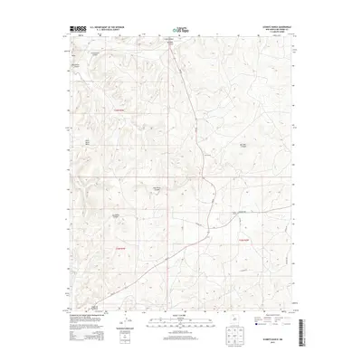
2013 Map of Schmitz Ranch
USGS Topo · Published 2013About this map
Wild Horse Mesa dominates the northern reaches of this Rio Arriba County landscape, where the high desert terrain is deeply incised by a series of significant drainages. The map reveals a land defined by its ranching and resource-extraction infrastructure, centering on the titular Schmitz Ranch and the nearby Ojito Camp. These outposts are connected by a network of rural routes, including NM-537 and several county roads like CO Road 405, which navigate the complex topography between Bull Well Canyon and Wild Horse Canyon. The presence of Tapicito Cr and the southern Cañon de los Ojitos highlights the essential watercourses that have shaped movement and land use in this part of New Mexico, providing a clear view of the area's rural development and survey boundaries.
Find a feature on this map
18 named features on this map. Tap any name to fly to it.
Don’t see what you’re looking for? This feature index may not catch every label — zoom into the map to look around manually.
Map Details
Editions of this 2013 Schmitz Ranch Map
This is the sole edition of this map. No revisions or reprints were ever made.
Other maps of this area

1889 · Largo
USGS Topo · 1:250,000

1895 · Largo
USGS Topo · 1:250,000

1954 · Aztec
USGS Topo · 1:250,000

1958 · Aztec
USGS Topo · 1:250,000

1962 · Aztec
USGS Topo · 1:250,000

1963 · Lapis Point
USGS Topo · 1:24,000

1963 · Schmitz Ranch
USGS Topo · 1:24,000

1963 · Otero Store
USGS Topo · 1:24,000

1963 · Lindrith
USGS Topo · 1:24,000
1963 · Ojito
USGS Topo · 1:24,000