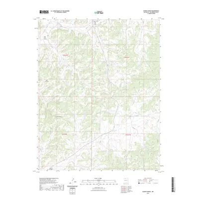
2023 Map of Schmitz Ranch
USGS Topo · Published 2023About this map
Tapicito Creek flows through the northern reaches of this Rio Arriba County landscape, carving a drainage pattern that defines the high desert terrain. The area is dominated by significant geographic features including the expansive Wild Horse Mesa and a network of deep incisions like Wild Horse Canyon and Las Norias Canyon. This modern survey illustrates a remote section of New Mexico where the Public Land Survey System grids of t26n r4w and t26n r3w meet. While the land remains largely undeveloped, the presence of various county roads and route 537 indicates contemporary access to these traditional ranching lands. Geologists and local land researchers can trace the complex contouring of the Cañon de los Ojitos in the south, reflecting the intricate natural erosion of the Colorado Plateau region.
Find a feature on this map
17 named features on this map. Tap any name to fly to it.
Don’t see what you’re looking for? This feature index may not catch every label — zoom into the map to look around manually.
Map Details
Editions of this 2023 Schmitz Ranch Map
This is the sole edition of this map. No revisions or reprints were ever made.
Other maps of this area

1889 · Largo
USGS Topo · 1:250,000

1895 · Largo
USGS Topo · 1:250,000

1954 · Aztec
USGS Topo · 1:250,000

1958 · Aztec
USGS Topo · 1:250,000

1962 · Aztec
USGS Topo · 1:250,000

1963 · Lapis Point
USGS Topo · 1:24,000

1963 · Schmitz Ranch
USGS Topo · 1:24,000

1963 · Otero Store
USGS Topo · 1:24,000

1963 · Lindrith
USGS Topo · 1:24,000
1963 · Ojito
USGS Topo · 1:24,000