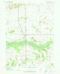
1959 Map of Schneider
USGS Topo · Published 1973About this map
The Kankakee River corridor dominates this late-1950s landscape, marking the transition from the marshland-turned-farmland of Lake County to Newton County. The town of Schneider serves as a local hub, situated at the crossroads of the New York Central railroad and a significant north-south highway. The engineering of the surrounding prairie is evident in the dense network of drainage projects such as Singleton Ditch, Grisel Ditch, and Fuller Ditch, which converted the once-vast Kankakee Marsh into productive agricultural ground.
Find a feature on this map
32 named features on this map. Tap any name to fly to it.
Don’t see what you’re looking for? This feature index may not catch every label — zoom into the map to look around manually.
Map Details
Editions of this 1959 Schneider Map
4 editions found
Other maps of this area

1922 · Momence
USGS Topo · 1:62,500

1924 · Momence
USGS Topo · 1:62,500

1949 · Crete
USGS Topo · 1:62,500

1953 · Leroy
USGS Topo · 1:24,000

1953 · Beecher East
USGS Topo · 1:24,000

1953 · Lowell
USGS Topo · 1:24,000

1953 · Chicago
USGS Topo · 1:250,000

1957 · Chicago
USGS Topo · 1:250,000

1959 · Schneider
USGS Topo · 1:24,000

1959 · Shelby
USGS Topo · 1:24,000