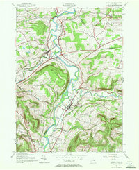
1943 Map of Schoharie
USGS Topo · Published 1972About this map
Schoharie and Central Bridge anchor this wartime landscape, situated where the Schoharie Creek valley meets the deep incision of Cobleskill Creek. The map documents a corridor of transit and history, most notably featuring the Old Stone Fort along the eastern bank of the river. The Delaware and Hudson railroad defines the valley floor, connecting nodes like Schoharie Junction and providing access for the surrounding upland agricultural communities.
Find a feature on this map
45 named features on this map. Tap any name to fly to it.
Don’t see what you’re looking for? This feature index may not catch every label — zoom into the map to look around manually.
Map Details
Editions of this 1943 Schoharie Map
4 editions found
Other maps of this area

1895 · Amsterdam
USGS Topo · 1:62,500

1896 · Fonda
USGS Topo · 1:62,500

1898 · Fonda
USGS Topo · 1:62,500

1898 · Schoharie
USGS Topo · 1:62,500

1900 · Schoharie
USGS Topo · 1:62,500

1900 · Schoharie
USGS Topo · 1:31,680

1900 · Berne
USGS Topo · 1:62,500

1902 · Fonda
USGS Topo · 1:62,500

1903 · Berne
USGS Topo · 1:62,500

1931 · Amsterdam
USGS Topo · 1:62,500