
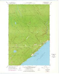
1955 Map of Schroeder
USGS Topo · Published 1957About this map
Lake Superior’s North Shore is defined here by the industrial emergence of the mid-1950s, most notably with the Erie Mining Company Railroad Under Construction and the developing Taconite Harbor. These features represent a pivotal era when the Iron Range's influence reached the coast to facilitate ore transport. The settlement of Schroeder sits at the mouth of the Cross River, while the inland landscape is a dense network of waterways like the Temperance River, Island River, and Fredenberg Creek. The map documents a rugged transition from the managed timberlands of the Superior National Forest and Finland State Forest to the coastal industrial sites. Notable local landmarks including a Radio Tower and the Taconite Plant provide specific points of interest for those studying the intersection of Minnesota's natural resources and the post-war industrial expansion.
Find a feature on this map
23 named features on this map. Tap any name to fly to it.
Don’t see what you’re looking for? This feature index may not catch every label — zoom into the map to look around manually.
Map Details
Editions of this 1955 Schroeder Map
2 editions found
Other maps of this area

1954 · Two Harbors
USGS Topo · 1:250,000

1955 · Tofte
USGS Topo · 1:24,000

1955 · Tofte
USGS Topo · 1:62,500

1955 · Cramer
USGS Topo · 1:62,500

1956 · Little Marais
USGS Topo · 1:24,000

1956 · Finland
USGS Topo · 1:62,500

1957 · Two Harbors
USGS Topo · 1:250,000

1958 · Two Harbors
USGS Topo · 1:250,000

1964 · Two Harbors
USGS Topo · 1:250,000

1976 · Two Harbors
USGS Topo · 1:100,000