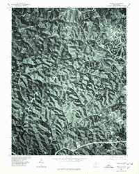
1975 Map of Schultz
USGS Topo · Published 1979About this map
Calcutta and Schultz anchor this mid-1970s orthophotoquad, which uses rectified aerial imagery rather than traditional line drawing to represent the ridge-and-valley landscape of Pleasants County. The dense canopy of West Virginia’s timberlands is interrupted by the winding corridors of local roads and small clearings that mark rural homesteads. This photographic survey, produced by the Geological Survey and the Soil Conservation Service, provides a raw look at the land use patterns of the era, from the small clusters of buildings at Glendale to the more isolated properties near Maxwell. The sharp relief of the hills and the deep shadows of the hollows illustrate the challenges and isolation of rural development in this part of the Ohio River Valley hinterlands.
Find a feature on this map
4 named features on this map. Tap any name to fly to it.
Don’t see what you’re looking for? This feature index may not catch every label — zoom into the map to look around manually.
Map Details
Editions of this 1975 Schultz Map
This is the sole edition of this map. No revisions or reprints were ever made.
Other maps of this area

1904 · Marietta
USGS Topo · 1:62,500

1906 · Saint Marys
USGS Topo · 1:62,500

1906 · Elizabeth
USGS Topo · 1:62,500

1907 · Harrisville
USGS Topo · 1:62,500

1924 · St Marys
USGS Topo · 1:62,500

1924 · Harrisville
USGS Topo · 1:62,500

1924 · Marietta
USGS Topo · 1:62,500

1924 · Elizabeth
USGS Topo · 1:62,500

1926 · Elizabeth
USGS Topo · 1:62,500

1926 · Harrisville
USGS Topo · 1:62,500