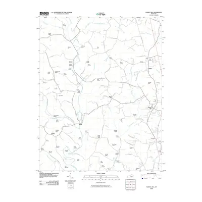
2010 Map of Science Hill
USGS Topo · Published 2010About this map
Fishing Creek and its many tributaries, including Puncheon Creek and Rock Lick Creek, carve through this section of Pulaski County. The landscape is defined by a dense network of ridges and hollows, such as Bethel Ridge, Beech Grove Ridge, and Tudy Hollow. The settlement of Science Hill serves as a primary hub in the east, while smaller communities like Ansel, Hogue, and Kingbee are scattered throughout the western rural reaches. Numerous family and community burial grounds, including the Dick Cemetery, Moore Cemetery, and Van Hook Cemetery, are documented across the terrain, offering significant data for genealogical research. The map illustrates a developed rural infrastructure where local life followed the natural contours of the land, from Higgins Flat to the narrow passage at The Narrows.
Find a feature on this map
117 named features on this map. Tap any name to fly to it.
Don’t see what you’re looking for? This feature index may not catch every label — zoom into the map to look around manually.
Map Details
Editions of this 2010 Science Hill Map
This is the sole edition of this map. No revisions or reprints were ever made.
Other maps of this area

1935 · Somerset
USGS Topo · 1:62,500

1952 · Eubank
USGS Topo · 1:24,000

1952 · Yosemite
USGS Topo · 1:24,000

1952 · Woodstock
USGS Topo · 1:24,000

1953 · Mintonville
USGS Topo · 1:24,000
1954 · Bobtown
USGS Topo · 1:24,000

1954 · Delmer
USGS Topo · 1:24,000

1954 · Science Hill
USGS Topo · 1:24,000
1954 · Somerset
USGS Topo · 1:24,000
1954 · Faubush
USGS Topo · 1:24,000