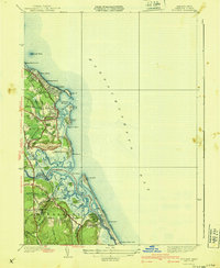
1940 Map of Scituate
USGS Topo · Published 1940About this map
The coastal geometry of the South Shore is meticulously detailed here, defined by the four distinctive drumlins known as First Cliff, Second Cliff, Third Cliff, and Fourth Cliff. These landforms protect Scituate Harbor and the winding marshes of the North River and South River. The landscape in the late 1930s shows a transitional phase of development, with established seaside communities like Shore Acres, Hatherly Beach, and Humarock connected by a network of local roads such as Country Way and Tilden Road.
Find a feature on this map
71 named features on this map. Tap any name to fly to it.
Don’t see what you’re looking for? This feature index may not catch every label — zoom into the map to look around manually.
Map Details
Editions of this 1940 Scituate Map
4 editions found
Other maps of this area

1885 · Abington
USGS Topo · 1:62,500

1885 · Duxbury
USGS Topo · 1:62,500

1888 · Duxbury
USGS Topo · 1:62,500

1888 · Abington
USGS Topo · 1:62,500

1892 · Boston Bay
USGS Topo · 1:62,500

1893 · Abington
USGS Topo · 1:62,500

1893 · Duxbury
USGS Topo · 1:62,500

1903 · Boston Bay
USGS Topo · 1:62,500

1918 · Duxbury
USGS Topo · 1:62,500

1920 · Abington
USGS Topo · 1:62,500