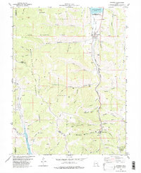
1979 Map of Scofield
USGS Topo · Published 1983About this map
Scofield and Clear Creek serve as the primary hubs in this high-altitude coal mining district during the late 1970s. The landscape is defined by the canyon-and-ridge topography of the Manti-La Sal National Forest, where industrial activity is deeply integrated into the terrain. Evidence of the region's energy economy is everywhere, from the Denver and Rio Grande Western railroad tracks following Mud Creek to numerous natural gas wells and coal mines like the Old Black Diamond Mine and O'Conner Mine. The presence of a Ski Lift near Clear Creek and the Scofield Lake State Recreation Area to the north signals a shift toward recreation alongside traditional resource extraction. Local genealogy and history are preserved at the Cem (cemetery) north of Scofield, while landmarks like Winter Quarters Ridge recall the area's difficult mining heritage.
Find a feature on this map
60 named features on this map. Tap any name to fly to it.
Don’t see what you’re looking for? This feature index may not catch every label — zoom into the map to look around manually.
Map Details
Editions of this 1979 Scofield Map
This is the sole edition of this map. No revisions or reprints were ever made.
Other maps of this area

1885 · Manti
USGS Topo · 1:250,000

1895 · Manti
USGS Topo · 1:250,000

1923 · Scofield
USGS Topo · 1:62,500

1925 · Scofield
USGS Topo · 1:62,500

1939 · Soldier Summit
USGS Topo · 1:62,500

1942 · Soldier Summit
USGS Topo · 1:62,500

1956 · Price
USGS Topo · 1:250,000

1960 · Price
USGS Topo · 1:250,000

1962 · Price
USGS Topo · 1:250,000

1965 · Huntington Reservoir
USGS Topo · 1:24,000