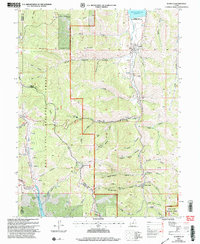
2001 Map of Scofield
USGS Topo · Published 2004About this map
Scofield and Clear Creek anchor this survey of high-elevation canyon country at the start of the twenty-first century. The landscape is defined by extensive energy extraction and water management, visible in the numerous industrial sites including the Skyline Mine, Belina Mine, and Old Black Diamond Mine, alongside several Gas Well labels. To the north, Scofield Reservoir and the Scofield Lake State Recreation Area provide a contrast to the industrial activity, while the southern boundary includes a portion of Electric Lake. The complex topography is marked by a dense network of drainages such as Eccles Canyon, Finn Canyon, and Slaughter House Canyon. For those researching local heritage, the map identifies the Cem in Scofield and various landmarks like the Recreation Center and several Communication Site locations, illustrating the modern infrastructure overlaid on a historic mining district.
Find a feature on this map
63 named features on this map. Tap any name to fly to it.
Don’t see what you’re looking for? This feature index may not catch every label — zoom into the map to look around manually.
Map Details
Editions of this 2001 Scofield Map
This is the sole edition of this map. No revisions or reprints were ever made.
Other maps of this area

1885 · Manti
USGS Topo · 1:250,000

1895 · Manti
USGS Topo · 1:250,000

1923 · Scofield
USGS Topo · 1:62,500

1925 · Scofield
USGS Topo · 1:62,500

1939 · Soldier Summit
USGS Topo · 1:62,500

1942 · Soldier Summit
USGS Topo · 1:62,500

1956 · Price
USGS Topo · 1:250,000

1960 · Price
USGS Topo · 1:250,000

1962 · Price
USGS Topo · 1:250,000

1965 · Huntington Reservoir
USGS Topo · 1:24,000