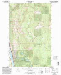
1992 Map of Scotchman Lake
USGS Topo · Published 1996About this map
Colville National Forest dominates this interior landscape of Pend Oreille County, defined by a network of drainage basins and isolated mountain peaks. The southwestern corner is anchored by the Pend Oreille River, where Le Clerc Road serves as the primary corridor for movement along the valley floor. Away from the river, the terrain rises sharply toward Molybdenum Mountain and Hanlon Mtn, revealing a wilderness dotted with high-altitude water bodies such as Deception Lake and Scotchman Lake.
Find a feature on this map
25 named features on this map. Tap any name to fly to it.
Don’t see what you’re looking for? This feature index may not catch every label — zoom into the map to look around manually.
Map Details
Editions of this 1992 Scotchman Lake Map
This is the sole edition of this map. No revisions or reprints were ever made.
Other maps of this area

1934 · Metaline
USGS Topo · 1:125,000

1942 · Metaline
USGS Topo · 1:125,000

1958 · Sandpoint
USGS Topo · 1:250,000

1963 · Sandpoint
USGS Topo · 1:250,000

1967 · Timber Mtn.
USGS Topo · 1:24,000

1967 · Ione
USGS Topo · 1:24,000

1967 · Scotchman Lake
USGS Topo · 1:24,000

1967 · Metaline
USGS Topo · 1:24,000

1967 · Metaline Falls
USGS Topo · 1:24,000

1967 · Monumental Mtn.
USGS Topo · 1:24,000