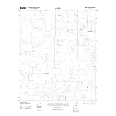
2012 Map of Scotland SE
USGS Topo · Published 2012About this map
The petroleum industry defines this corner of North Texas, where the Lazy B Oil Field and the McKinlay Oil Field indicate the ongoing legacy of the region's energy economy. This landscape is shaped by a grid of rural routes and creek beds, notably Scaling Lake and the various branches of Willow Cr and Lodge Cr. Several prominent country roads, including Bill Gilmore Rd, Wilson Rd, and the curiously named Gasoline Alley Rd, connect isolated homesteads and drilling sites. The map illustrates a rural landscape in 2012 where the infrastructure of local ranching and the oil patch are deeply intertwined, visible in the network of farm-to-market roads like FM-174 and family-named thoroughfares such as Hugh Henderson Rd and Raymond Edwards Rd.
Find a feature on this map
24 named features on this map. Tap any name to fly to it.
Don’t see what you’re looking for? This feature index may not catch every label — zoom into the map to look around manually.
Map Details
Editions of this 2012 Scotland SE Map
This is the sole edition of this map. No revisions or reprints were ever made.
Other maps of this area

1954 · Wichita Falls
USGS Topo · 1:250,000

1958 · Wichita Falls
USGS Topo · 1:250,000

1962 · Windthorst
USGS Topo · 1:24,000

1962 · Antelope Creek NE
USGS Topo · 1:24,000

1963 · Deer Creek
USGS Topo · 1:24,000

1963 · Scotland
USGS Topo · 1:24,000

1964 · Darnell Branch
USGS Topo · 1:24,000

1964 · Antelope
USGS Topo · 1:24,000

1964 · Scotland SE
USGS Topo · 1:24,000
1964 · Postoak
USGS Topo · 1:24,000