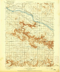
1898 Map of Scotts Bluff
USGS Topo · Published 1918About this map
The North Platte River carves a dominant path through this landscape, flanked by a complex network of early irrigation infrastructure including the Enterprise Canal, Farmers Canal, and Quincy Canal. This survey, conducted in the 1890s, documents the early development of the Nebraska Panhandle as the Chicago Burlington and Quincy Railroad began to shape the growth of towns like Mitchell, Gering, and Scottsbluff. South of the river valley, the dramatic escarpments of the Wildcat Hills rise sharply, punctuated by landmarks such as Scotts Bluff, Dome Rock, and Castle Rock. Significant early crossings like Roubedeau Pass and Mitchell Pass are clearly marked, alongside now-sparse settlements such as Ashford, Larissa, and Dorrington. In Banner Co., the isolated village of Harrisburg sits amidst a terrain of spring-fed draws like Willow Springs and Gabe Springs.
Find a feature on this map
61 named features on this map. Tap any name to fly to it.
Don’t see what you’re looking for? This feature index may not catch every label — zoom into the map to look around manually.
Map Details
Editions of this 1898 Scotts Bluff Map
5 editions found
Other maps of this area

1896 · Patrick
USGS Topo · 1:125,000

1898 · Scotts Bluff
USGS Topo · 1:125,000

1898 · Camp Clarke
USGS Topo · 1:125,000

1899 · Goshen Hole
USGS Topo · 1:125,000

1899 · Whistle Creek
USGS Topo · 1:125,000

1951 · Kilpatrick Lake
USGS Topo · 1:62,500

1954 · Scottsbluff
USGS Topo · 1:250,000

1954 · Torrington
USGS Topo · 1:250,000

1954 · Cheyenne
USGS Topo · 1:250,000

1955 · Alliance
USGS Topo · 1:250,000