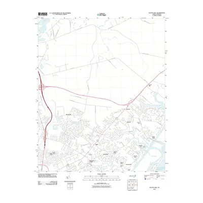
2010 Map of Scotts Hill
USGS Topo · Published 2010About this map
Middle Sound and the complex tidal inlets of the Atlantic coast define the eastern edge of this 2010 landscape. Residential development is highly concentrated south of the major highway interchanges, where established neighborhoods like Murraysville, Ogden, and Westwood Heights are shown in detail. In contrast, the northern portion of the map remains largely dominated by timber tracts and undeveloped land, accessible only by a grid of rural routes such as Holly Shelter Rd and Sidbury Rd. This map captures the distinct boundary between suburban expansion and the natural drainage systems of Island Creek and Prince George Creek. Local history is anchored by Prospect Cemetery, while the coastal economy is represented by Masons Marina and the residential enclaves of Porters Neck and Bayshore overlooking the water.
Find a feature on this map
53 named features on this map. Tap any name to fly to it.
Don’t see what you’re looking for? This feature index may not catch every label — zoom into the map to look around manually.
Map Details
Editions of this 2010 Scotts Hill Map
This is the sole edition of this map. No revisions or reprints were ever made.
Other maps of this area

1942 · Topsail
USGS Topo · 1:62,500

1942 · Wilmington
USGS Topo · 1:62,500

1947 · Rocky Point
USGS Topo · 1:62,500

1948 · Topsail
USGS Topo · 1:62,500

1948 · Wilmington
USGS Topo · 1:62,500

1953 · Beaufort
USGS Topo · 1:250,000

1954 · Beaufort
USGS Topo · 1:250,000

1970 · Hampstead
USGS Topo · 1:24,000
1970 · Wrightsville Beach
USGS Topo · 1:24,000

1970 · Topsail
USGS Topo · 1:24,000