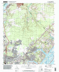
1997 Map of Scotts Hill
USGS Topo · Published 2000About this map
The coastal transition of New Hanover County is captured here in the late 1990s, where inland developments like Kings Grant and Murraysville meet the labyrinthine tidal waters of the Atlantic coast. The map illustrates a landscape defined by its relation to the water, from the Cape Fear R in the west to the Middle Sound and Intracoastal Waterway in the east. Settlements such as Porters Neck and Ogden show significant residential expansion, yet the map retains evidence of older community anchors including Oak Grove Ch, Middle Sound Ch, and Prospect Cem.
Find a feature on this map
27 named features on this map. Tap any name to fly to it.
Don’t see what you’re looking for? This feature index may not catch every label — zoom into the map to look around manually.
Map Details
Editions of this 1997 Scotts Hill Map
This is the sole edition of this map. No revisions or reprints were ever made.
Other maps of this area

1942 · Topsail
USGS Topo · 1:62,500

1942 · Wilmington
USGS Topo · 1:62,500

1947 · Rocky Point
USGS Topo · 1:62,500

1948 · Topsail
USGS Topo · 1:62,500

1948 · Wilmington
USGS Topo · 1:62,500

1953 · Beaufort
USGS Topo · 1:250,000

1954 · Beaufort
USGS Topo · 1:250,000

1970 · Hampstead
USGS Topo · 1:24,000
1970 · Wrightsville Beach
USGS Topo · 1:24,000

1970 · Topsail
USGS Topo · 1:24,000