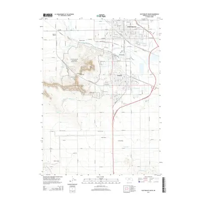
2014 Map of Scottsbluff South
USGS Topo · Published 2014About this map
Scotts Bluff National Monument dominates the topography of this Western Nebraska landscape, where the landmark heights of Scotts Bluff and Eagle Rock overlook the historic Mitchell Pass. This 2014 survey captures the significant irrigation infrastructure essential to the region, including the Fort Laramie Canal, Gering Canal, and Winters Cr Canal that feed the surrounding valleys. The urban centers of Scottsbluff and Gering are shown in high detail, flanking the North Platte River and connected by an extensive network of streets and railroads such as W Railway St. To the west, the map details smaller locales like Terrytown and Costin, alongside prominent natural features like Sentinel Rock and Dome Rock. For genealogists, the W Lawn Cem provides a specific point of interest within the city limits of Gering.
Find a feature on this map
110 named features on this map. Tap any name to fly to it.
Don’t see what you’re looking for? This feature index may not catch every label — zoom into the map to look around manually.
Map Details
Editions of this 2014 Scottsbluff South Map
This is the sole edition of this map. No revisions or reprints were ever made.
Other maps of this area

1898 · Scotts Bluff
USGS Topo · 1:125,000

1954 · Scottsbluff
USGS Topo · 1:250,000

1958 · Scottsbluff
USGS Topo · 1:250,000

1963 · Scottsbluff South
USGS Topo · 1:24,000

1963 · Mitchell
USGS Topo · 1:24,000

1963 · Scottsbluff North
USGS Topo · 1:24,000

1963 · Roubadeau Pass
USGS Topo · 1:24,000

1965 · Minatare
USGS Topo · 1:24,000
1965 · Lake Alice
USGS Topo · 1:24,000

1973 · Scotts Bluff 4 NW
USGS Topo · 1:24,000