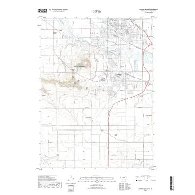
2017 Map of Scottsbluff South
USGS Topo · Published 2017About this map
Scotts Bluff National Monument dominates the western landscape of this Nebraska survey, showcasing the dramatic transition from the North Platte River valley to the high plains. The map details an intricate network of early 21st-century irrigation infrastructure, including the Winters Cr Canal, Mitchell and Gering Canal, and the Fort Laramie Canal, which have long supported the region's agricultural economy.
Find a feature on this map
48 named features on this map. Tap any name to fly to it.
Don’t see what you’re looking for? This feature index may not catch every label — zoom into the map to look around manually.
Map Details
Editions of this 2017 Scottsbluff South Map
This is the sole edition of this map. No revisions or reprints were ever made.
Other maps of this area

1898 · Scotts Bluff
USGS Topo · 1:125,000

1954 · Scottsbluff
USGS Topo · 1:250,000

1958 · Scottsbluff
USGS Topo · 1:250,000

1963 · Scottsbluff South
USGS Topo · 1:24,000

1963 · Mitchell
USGS Topo · 1:24,000

1963 · Scottsbluff North
USGS Topo · 1:24,000

1963 · Roubadeau Pass
USGS Topo · 1:24,000

1965 · Minatare
USGS Topo · 1:24,000
1965 · Lake Alice
USGS Topo · 1:24,000

1973 · Scotts Bluff 4 NW
USGS Topo · 1:24,000