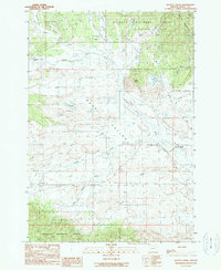
1990 Map of Scotty Creek
USGS Topo · Published 1990About this map
Bear Valley dominates this high-country landscape in Grant County, where the headwaters of the Silvies River meander through a wide mountain basin. This 1990 provisional survey records a rugged interior region of the Malheur National Forest, defined by the prominent Aldrich Mountains and Starr Ridge to the northeast. The map provides a clear look at the area's ranching heritage, showing established operations like Lowe Ranch, Holliday Ranch, and 96 Ranch situated near the valley floor. Water distribution is a central theme, with numerous diversion ditches and springs feeding into the drainage network of Scotty Creek and Damon Creek. The terrain transitions from the open glades of Wymer and Long Glade in the west toward the steep elevations of Windy Point, offering a detailed view of the forest boundary and the isolated outposts that characterize this part of eastern Oregon.
Find a feature on this map
28 named features on this map. Tap any name to fly to it.
Don’t see what you’re looking for? This feature index may not catch every label — zoom into the map to look around manually.
Map Details
Editions of this 1990 Scotty Creek Map
This is the sole edition of this map. No revisions or reprints were ever made.
Other maps of this area

1940 · Mount Vernon
USGS Topo · 1:62,500

1940 · John Day
USGS Topo · 1:62,500

1943 · John Day
USGS Topo · 1:62,500

1943 · Mount Vernon
USGS Topo · 1:62,500

1955 · Canyon City
USGS Topo · 1:250,000

1959 · Canyon City
USGS Topo · 1:250,000

1961 · Logdell
USGS Topo · 1:62,500

1961 · Seneca
USGS Topo · 1:62,500

1972 · Canyon Mtn
USGS Topo · 1:24,000
1972 · Mc Clellan Mtn
USGS Topo · 1:24,000