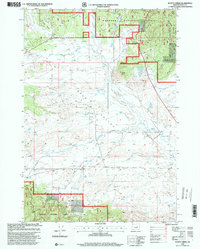
1998 Map of Scotty Creek
USGS Topo · Published 2000About this map
Malheur National Forest boundaries define the high-country landscape of this Grant County survey, where the Aldrich Mountains and Starr Ridge overlook the broad drainage of Bear Valley. The land use here is dictated by water management, visible in the network of diversion ditches that pull from the Silvies River and its various tributaries to support the high-altitude ranching and timber environment. Near the center of the valley floor, the small settlement of McCurdy sits amidst a web of seasonal streams and springs.
Find a feature on this map
17 named features on this map. Tap any name to fly to it.
Don’t see what you’re looking for? This feature index may not catch every label — zoom into the map to look around manually.
Map Details
Editions of this 1998 Scotty Creek Map
This is the sole edition of this map. No revisions or reprints were ever made.
Other maps of this area

1940 · Mount Vernon
USGS Topo · 1:62,500

1940 · John Day
USGS Topo · 1:62,500

1943 · John Day
USGS Topo · 1:62,500

1943 · Mount Vernon
USGS Topo · 1:62,500

1955 · Canyon City
USGS Topo · 1:250,000

1959 · Canyon City
USGS Topo · 1:250,000

1961 · Logdell
USGS Topo · 1:62,500

1961 · Seneca
USGS Topo · 1:62,500

1972 · Canyon Mtn
USGS Topo · 1:24,000
1972 · Mc Clellan Mtn
USGS Topo · 1:24,000