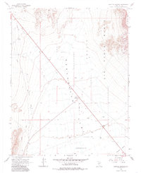
1968 Map of Scottys Junction
USGS Topo · Published 1985About this map
Sarcobatus Flat dominates this high-desert landscape in Nye County, showing the intersection of transit and topography in the late 1960s. The small settlement of Scottys Junction serves as the focal point, positioned where highways meet the expansive basin floor. Evidence of the region’s earlier infrastructure is preserved in the form of an Old Railroad Grade running through the northwestern sector, while the eastern portion of the map is defined by the high elevations of Pahute Mesa and the boundary of the Nellis Air Force Range.
Find a feature on this map
19 named features on this map. Tap any name to fly to it.
Don’t see what you’re looking for? This feature index may not catch every label — zoom into the map to look around manually.
Map Details
Editions of this 1968 Scottys Junction Map
2 editions found
Other maps of this area

1908 · Kawich
USGS Topo · 1:250,000

1908 · Lida
USGS Topo · 1:250,000

1913 · Lida
USGS Topo · 1:250,000

1942 · Tolicha Peak
USGS Topo · 1:125,000

1954 · Goldfield
USGS Topo · 1:250,000

1955 · Goldfield
USGS Topo · 1:250,000

1958 · Goldfield
USGS Topo · 1:250,000

1962 · Goldfield
USGS Topo · 1:250,000
1966 · Springdale
USGS Topo · 1:62,500

1968 · Stonewall Pass
USGS Topo · 1:24,000